SELINA
![]() Department of Integrated Geography participates in the new Horizon Europe program entitled Science for Evidence-based and sustainabLe decIsions about NAtural capital (HORIZON-CL6-2021-BIODIV-01-07). The project’s main objective is to provide scientific information to support the conservation, restoration, and sustainable and climate-neutral use of ecosystems in the EU by 2030. Key project challenges include exploring the relationship between biodiversity and ecosystem services and integrating them into EU policy. The consortium brings together experts from all EU Member States, Associated Countries and Overseas Regions of the EU, and stakeholders from various public and business sectors. The project involves leading experts in multiple fields of science (environmentalists, economists, sociologists) and science-politics-business contacts who previously participated in related activities (OpenNESS, ESMERALDA, MAIA, MAES, ESP, IPBES, BD Partnership). The total budget of the project is 13 million. € and its execution is planned for five years.
Department of Integrated Geography participates in the new Horizon Europe program entitled Science for Evidence-based and sustainabLe decIsions about NAtural capital (HORIZON-CL6-2021-BIODIV-01-07). The project’s main objective is to provide scientific information to support the conservation, restoration, and sustainable and climate-neutral use of ecosystems in the EU by 2030. Key project challenges include exploring the relationship between biodiversity and ecosystem services and integrating them into EU policy. The consortium brings together experts from all EU Member States, Associated Countries and Overseas Regions of the EU, and stakeholders from various public and business sectors. The project involves leading experts in multiple fields of science (environmentalists, economists, sociologists) and science-politics-business contacts who previously participated in related activities (OpenNESS, ESMERALDA, MAIA, MAES, ESP, IPBES, BD Partnership). The total budget of the project is 13 million. € and its execution is planned for five years.
For more details about SELINA please visit the project website https://www.project-selina.eu/
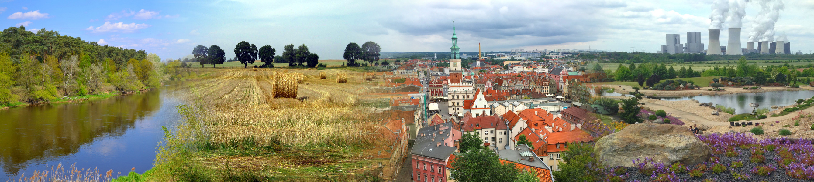
Services provided by main types of ecosystems in Poland – an applied approach
![]()
![]() The Department of Integratetd Geography as a promoter implements a project entitled Services provided by the main types of ecosystems in Poland – an applied approach. The main objective of the project is to transfer general and detailed scientific knowledge about ecosystem services existing in Europe to the process of identifying and evaluating ecosystem services in Poland. This requires integrating developed scientific knowledge into the interests and competences of officials, as well as the skills of experts involved in procedures.
The Department of Integratetd Geography as a promoter implements a project entitled Services provided by the main types of ecosystems in Poland – an applied approach. The main objective of the project is to transfer general and detailed scientific knowledge about ecosystem services existing in Europe to the process of identifying and evaluating ecosystem services in Poland. This requires integrating developed scientific knowledge into the interests and competences of officials, as well as the skills of experts involved in procedures.
More informations on Project site
TeRRIFICA (Accomplished)
Department of Integrated Geography and Regional Analysis Department participate, with other 7 partners from Europe, in TeRRIFICA Project – Territorial RRI Fostering Innovative Climate Action, funded from the European Union’s Horizon 2020 research and innovation programme (grant agreement No. 824489, H2020-SwafS-2018-2020 Science with and for Society). Project will set up tailored roadmaps and key performance indicators for the implementation of the developed methodologies and climate change adaptation activities in regional practice. Customized capacity building for the different stakeholder groups will be offered. Through workshops, regional and international summer schools, TeRRIFICA aims to empower local people (with a particular focus on regional authorities and policy makers) and will develop together with them adequate solutions. Field trips to local and regional promising activities related to research and regional innovation, and broader stakeholder engagement with feedback loops will be organized. Through its co-creative multi-stakeholder approaches, participants have the opportunity to expand their knowledge around climate change and innovative climate action and to identify opportunities, drivers and barriers of implementation. Activities take into account challenges for the acceptance and feasibility, technological and regulatory constraints in six pilot regions. TeRRIFICA started in January 2019 and will run for 42 months, till end of June 2022.
Project aims at fostering competence for climate change adaptation in different European regions and its goals are: 1) to develop action plans together with diverse actors on how regional climate change adaptation measures can be implemented; 2) to transfer these measures to other regions; and 3) to broaden the experience with various cooperation formats, which are suitable to arouse the interest for engagement in climate change adaptation in the different target groups.
Our team is involved in the implementation of all work packages, but the specific role is to develop a crowd-mapping tool for a recognition of the role of green, blue and grey infrastructure in climate action in the six pilot regions in Europe.
More information about this project could be found in leaflet, at the websites terrifica.eu, http://igsegp.amu.edu.pl/terrifica/ and in social media profiles Flickr, Twitter.
The CONNECTING Nature (Accomplished)
![]()
Department of Integrated Geography participate, with other 28 partners from Europe, in CONNECTING Nature Project – COproductioN with NaturE for City Transitioning, INnovation and Governance, funded from the European Union’s Horizon 2020 research and innovation programme (grant agreement No. 730222). The overarching objective of this Project is to position Europe as a global leader in the innovation and implementation of nature-based solutions. CONNECTING Nature started in June 2017 and will run for 60 months, till end of May 2022.
Our team strictly cooperate with City of Poznań which is one of the tree front-runner cities in this Project (together with Genk and Glasgow). We are involved especially in the tasks and actions under the Work Package 3 which overall objective is to showcase, and share learning from, the scaling-up, replication and integration of nature-based solutions for city-making within front-runner cities.
More information about this project could be found here.
Esmeralda (Accomplished)
Department of Integrated Geography participate, with other 35 partners from Europe, in the ESMERALDA Project – Enhancing ecoSysteM sERvices mApping for poLicy and Decision mAking, funded from the European Union’s Horizon 2020 research and innovation programme (grant agreement No. 642007). This Project aims to deliver a ‘flexible methodology’ that can simultaneously provide innovative building blocks for pan-European, national and regional ES mapping and assessment. ESMERALDA started in February 2015 and will run for 42 months, till end of July 2018.
Our team contribute to several tasks:
- Determination what the relevant stakeholders expect from ES mapping;
- Identification of suitability existing ES maps in Poland for an implementation by policy makers and other stakeholders;
- Analyze of ES assessment for Poland regarding to the role of scaling, synergies or trade-offs, their shifting in time and space and as well reversibility;
- Testing of possibility to include a new data, indicators and processing methods for next generations of ES maps.
More information about this project could be found here.